In today’s digital farming era, we’re helping farmers make smarter, data-driven decisions that maximize yield, reduce costs, and promote sustainability. By integrating high-resolution drone and satellite imagery with real-time Internet of Things (IoT) field data, our AI-powered platform provides actionable insights to monitor, forecast, and improve every phase of crop production.
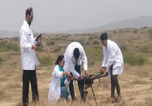
Field Surveys
Our precision agriculture process begins with conducting a comprehensive aerial and ground surveys of agricultural fields using advanced drone platforms. These surveys capture high-resolution RGB and multispectral imagery, providing a complete visual and spatial overview of the agriculture land.
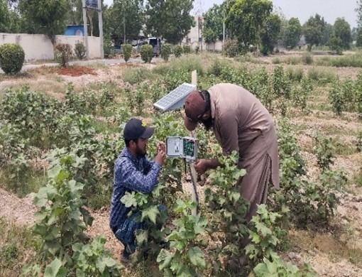
Internet of Things
To complement the aerial data, we have installed IoT nodes across the agriculture field to continuously monitor soil and weather parameters such as moisture, temperature, humidity, and nutrient levels. This ground-level data enhances the accuracy and contextual understanding of crop conditions.
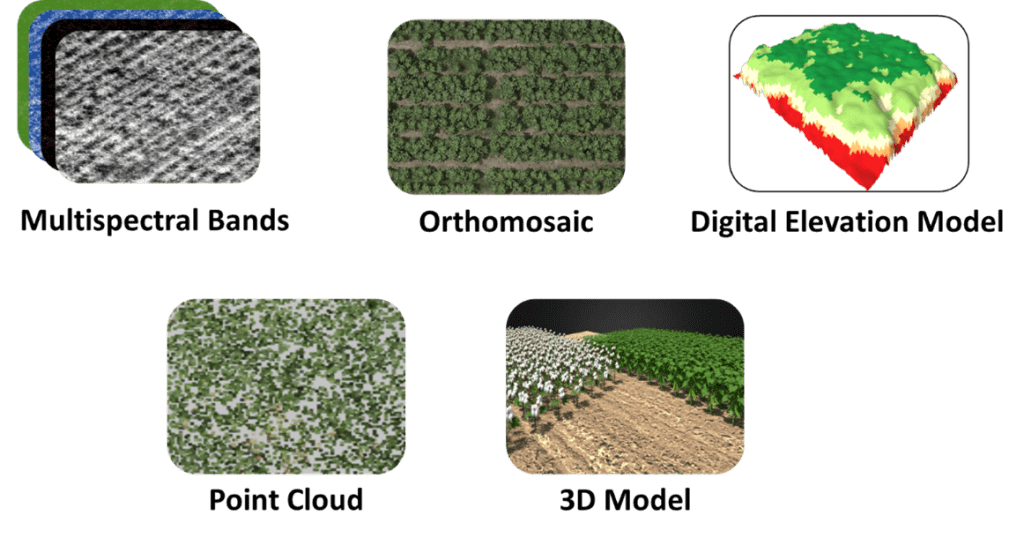
Aerial Data Products
The captured aerial data has been processed to generate specialized geospatial products that form the foundation for AI-based agricultural insights.
In addition to drone-based surveys, satellite imagery is also utilized to provide wide-scale monitoring of agricultural fields. By seamlessly integrating satellite, drone, and IoT data, our system ensures comprehensive, multi-source precision and reliability.
Unlock Growth with Smart Precision
Our smart farming portfolio integrates AI-powered solutions that transform raw data of agriculture field into actionable insights, enhancing farm efficiency and profitability.
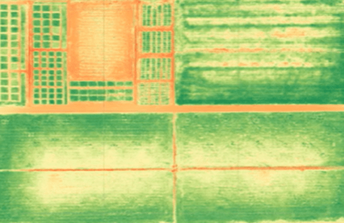
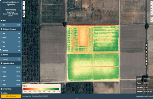
Crop Health Monitoring
Unlock field-scale clarity with high-resolution multispectral mosaics to map land cover, monitor crop health, and detect nutrient deficiencies using vegetation indices, helping you optimize every acre with precision.
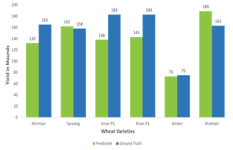
Yield Estimation
Generate precise yield forecasts for crops like Wheat and Cotton using AI-driven analysis of agriculture field data.
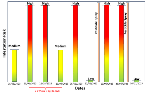
Pest Prediction
Forecast pest threats like jassids, thrips, pink bollworms in Cotton fields, delivering timely alerts to protect the crop.
Tree/ Row/ Stand Count
Delivers precise plant and row counts across agriculture field giving farmers early visibility into crop emergence, spacing, and gaps.
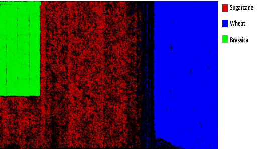
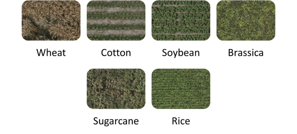
Crop Classification
Leveraging high-resolution satellite/ drone imagery with AI to precisely map every crop type, enabling smarter planning and reporting across farms.
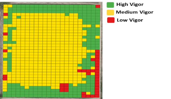
Crop Vigor Analysis
Get a comprehensive view of crop growth trend with AI-powered vigor analysis tool to deliver clear insights about crop performance throughout the season.
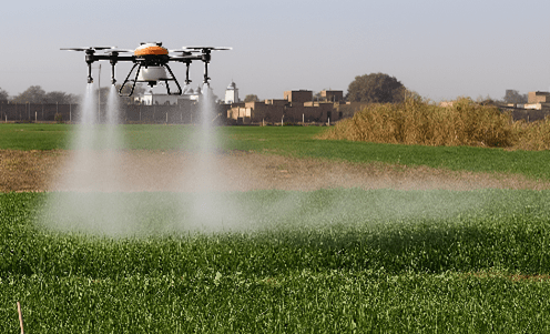
Variable Rate Spraying
Precision spraying service that integrates vigor analysis, agronomist expertise, and UAV technology to determine and apply the optimal fertilizer dose for every field zone.
Data Visualization
All AI-driven crop insights are visualized through a unified and interactive dashboard, integrating data from drones, satellites, IoT sensors.
Key Benefits of AI-Powered Precision Agriculture Solution
Combines satellite, drone, and IoT data to deliver accurate, field-level intelligence across large and small farm areas.
Digital Elevation Model layer assist in effective water management and field planning.
Identifies crop stress, pest pressure, and nutrient deficiencies before their impact.
Provides accurate yield predictions for better harvest planning, logistics, and market decisions.
Enables targeted fertilizer applications through Variable Rate Spraying reducing wastage, achieves significant savings up to 50% and optimizing input use.